
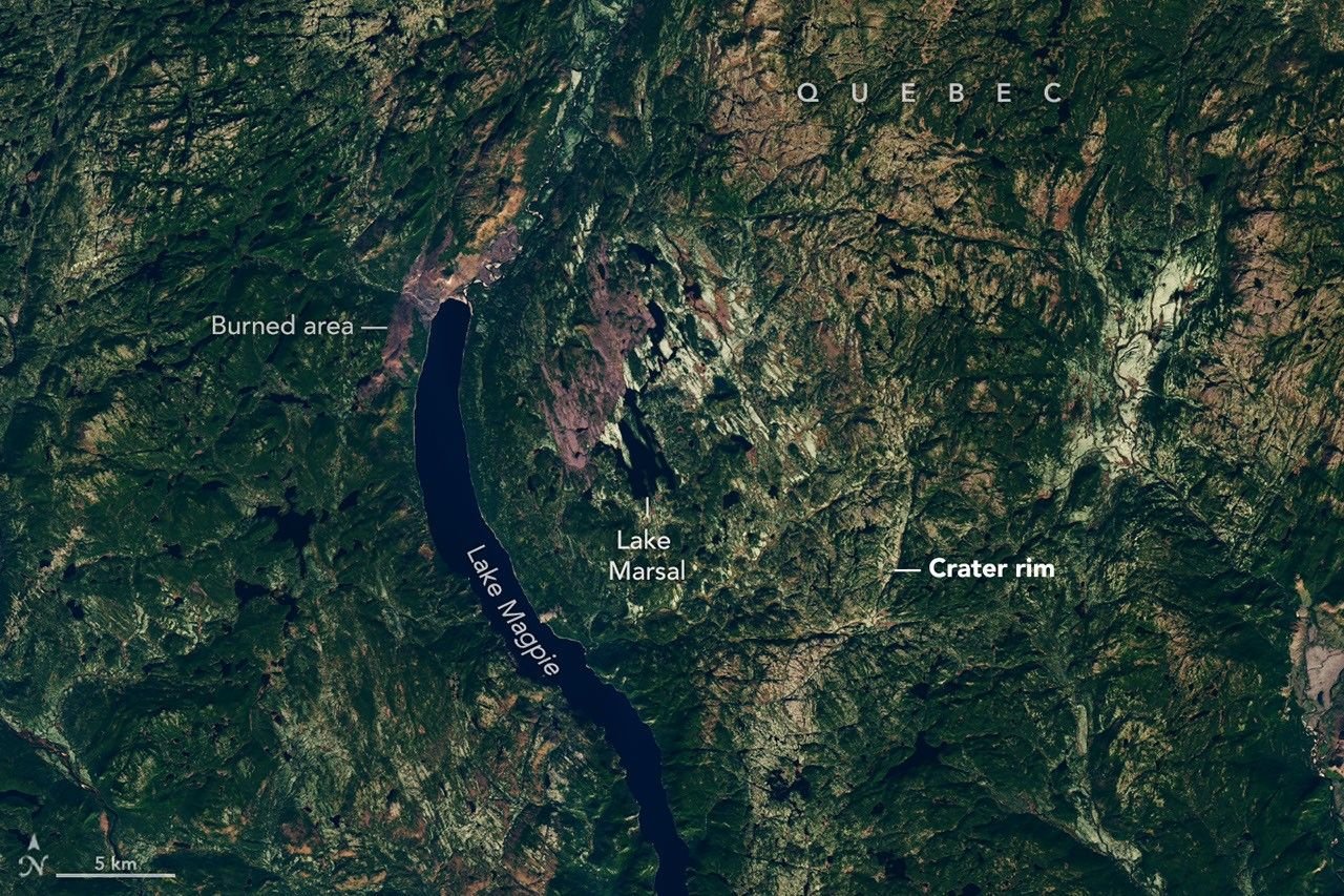
A search for a campsite led to something much older and much larger: evidence of a 25-kilometre-wide impact structure hidden in Quebec’s landscape.
The Uhackatik crater story received a fresh illustrated account from NASA Earth Observatory on 15 September 2026. The initial clue was noticed in 2024, when amateur astronomer Joël Lapointe was studying online satellite maps near Lake Marsal. He contacted specialists about a circular feature that looked unusual. NASA’s account
It is an appealing discovery story because the first instrument was something millions of people can use: a map on a screen. But the map started the investigation. It did not, on its own, establish a meteorite impact.
The rocks changed the case
Researchers visited the site in October 2025 to examine the geology and collect samples. Their conference abstract reports shatter cones—distinctive rock structures produced by intense shock—and interprets a formation previously associated with volcanic activity as impact melt rock. Research abstract presented to the Meteoritical Society
The team estimates that the structure formed roughly 390 million years ago. Its dating evidence includes the magnetic direction recorded in rocks, with preliminary mineral measurements providing another check. The estimate has uncertainty; it is not a precisely known anniversary. Methods and age estimate
This is what makes the scientific case stronger than an intriguing outline. Independent kinds of evidence point towards the same explanation.
Large enough to reshape a landscape
At around 25 kilometres across, the structure spans a distance comparable to a substantial journey across a city. That is the crater’s estimated diameter, not the size of the object that struck Earth.
NASA describes a complex impact structure with a central uplift and substantial cliffs. The researchers consider its impact origin confirmed, while NASA’s report says formal recognition by a Meteoritical Society committee is still expected. The name was chosen after consultation with the Innu Council of Ekuanitshit. NASA
Those distinctions deserve to survive the headline. This is an ancient geological feature under investigation, not evidence of a newly arriving threat.
The published research summary also makes the stage of the evidence clear: the linked document is a conference abstract. Readers should not mistake that short account for a complete new peer-reviewed journal paper containing every measurement.
Public imagery creates a larger search team
Our reading of the story is that public access to satellite views can widen the pool of people who notice useful clues. A person does not need to arrive with a finished scientific explanation to ask a good question.
The follow-up remains essential. A circular landscape can suggest several origins, and researchers must test those alternatives. Here, the combination of fieldwork, rock structures and dating information supplied the argument that the image alone could not.
This complements the very different challenge of spotting fresh impacts on the Moon. On Earth, the question may concern a scar altered and obscured over immense spans of time, rather than a new mark visible between two recent photographs.
Uhackatik is a reminder that familiar mapping tools can still point towards unfamiliar science. The discovery began with someone noticing a shape—and became persuasive when a team went to see what the rocks had to say.
Featured image: Landsat 8 view of the Uhackatik structure, with Lake Marsal near the centre, captured on 12 October 2025. Image: NASA Earth Observatory / Lauren Dauphin, using USGS Landsat data.
Leave a Reply